

Your Complete Guide to the Annapurna Circuit’s Legendary High Pass
Thorong La Pass is a high Himalayan mountain pass located at 5,416m (17,750 ft) in Nepal’s Annapurna Conservation Area. It is the highest and most dramatic point on the Annapurna Circuit trek, connecting the village of Manang in the east to Muktinath in the west. Crossing Thorong La Pass is physically demanding due to high altitude and steep terrain, but with proper preparation and acclimatization, most fit trekkers can complete it successfully.
What is Thorong La Pass?
Standing higher than Everest Base Camp Trek (5,380m/17,650ft), Thorong La Pass is not just a mountain pass, it is the crown jewel of the Annapurna Circuit Trek (5,416m/17,769ft). Every year, thousands of trekkers from around the world set out before dawn from Thorong Phedi or High Camp, headlamps cutting through the darkness, working toward one of the most rewarding achievements in Himalayan trekking.
So what exactly is Thorong La Pass? How hard is the crossing? And what do you need to know before you attempt it? This guide answers all of that with real insights from experienced Himalayan guides, practical data, and everything you need to plan a safe and successful crossing.
What Exactly is Thorong La Pass?
Thorong La Pass (also spelled Thorung La) is a high mountain pass in the Mustang District of northern Nepal. It sits at 5,416m (17,750 ft) above sea level, making it one of the highest trekking passes in the world.
Key Facts About Thorong La Pass
| Detail | Information |
| Full Name | Thorong La Pass (Thorung La) |
| Altitude | 5,416m / 17,750 ft |
| Location | Mustang District, Gandaki Province, Nepal |
| Trekking Route | Annapurna Circuit Trek |
| Crossing Direction | East to West (Manang to Muktinath) |
| Starting Point | Thorong Phedi (4,450m) or High Camp (4,850m) |
| End Point | Muktinath (3,710m) |
| Higher Than | Everest Base Camp (5,380m) |
| Distance (pass day) | Approx. 16km (10 miles) |
| Elevation Gain | Approx. 1,000m (3,280 ft) from High Camp |
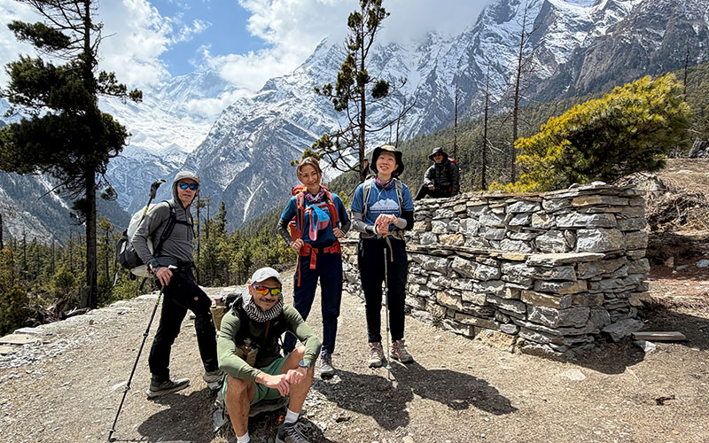
The pass acts as a geographic gateway between the lush Marshyangdi Valley to the east and the arid, high-altitude Mustang plateau to the west. The landscape changes dramatically as you cross from glacier-carved Himalayan peaks to a desert-like rain shadow zone beyond Muktinath.
For internal reference, you can explore the full Annapurna Circuit trek details at Himalayan Glacier’s Annapurna Circuit Trek page.
How Hard is the Thorong La Pass Crossing?
The Thorong La Pass crossing is rated as challenging, primarily because of the altitude and the length of the summit day, not technical climbing. Most physically fit and properly acclimatized trekkers can complete it without mountaineering experience.
Quick Facts:
- Altitude: 5,416m / 17,750 ft
- Best Season: March-May, October-November
- Trek Duration: 12-21 Days (Annapurna Circuit)
- Difficulty: Challenging
What Makes It Hard?
- Extreme altitude (5,416m/17,769ft) – oxygen levels are roughly 50% of what you breathe at sea level
- Long summit day – typically 7 to 9 hours of continuous trekking
- Steep ascent from High Camp to the pass summit (around 600-700m elevation gain in 4-5 hours)
- Unpredictable weather – sudden snowfall, blizzards, and high winds can occur year-round
- Cold temperatures at the pass can drop to -10 degrees C or below, even in October
- The descent to Muktinath (1,700m drop over 7-8 km) puts heavy strain on knees
Difficulty Rating Comparison
| Pass / Route | Altitude | Difficulty |
| Thorong La Pass | 5,416m (17,750 ft) | Challenging |
| Everest Base Camp Trek | 5,380m (17,598 ft) | Moderate-Challenging |
| Gokyo Ri | 5,357m (17,575 ft) | Moderate |
| Renjo La Pass | 5,360m (17,585 ft) | Challenging |
| Kala Patthar | 5,645m (18,519 ft) | Challenging |
Our guides at Himalayan Glacier recommend: “The pass itself is not technical, no ropes or crampons are required under normal conditions. What makes it hard is the altitude and the mental stamina required for such a long, cold, early-morning push. The key is preparation and pacing.”
Plan Your Thorong La Pass Crossing
Our on-ground Nepal team and USA-based support office help you plan every detail – from acclimatization days to guide support at the pass. Don’t leave it to chance.
What is the Thorong La Pass Elevation, and Why Does it Matter?
The Thorong La Pass elevation of 5,416m (17,750 ft) places it in a zone where altitude sickness becomes a genuine concern for all trekkers, regardless of fitness level.
Altitude and Oxygen: What Happens to Your Body
At 5,416m/17,750 ft, the air pressure drops to around 50-55% of sea level. This means every breath delivers roughly half the oxygen your body is used to. Symptoms of Acute Mountain Sickness (AMS) can include:
- Headaches and dizziness
- Nausea or vomiting
- Fatigue and poor sleep
- Loss of appetite
- Shortness of breath even at rest
Acclimatization Schedule (Recommended)
| Location | Altitude | Nights Recommended |
| Chame | 2,710m (8,891 ft) | 1 night |
| Manang | 3,519m (11,545 ft) | 2 nights (acclimatize here) |
| Yak Kharka | 4,018m (13,183 ft) | 1 night |
| Thorong Phedi / High Camp | 4,450m – 4,850m | 1 night |
| Cross Thorong La Pass | 5,416m (17,750 ft) | Pass day – descend to Muktinath |
Most trekkers experience mild symptoms around Manang and Yak Kharka. This is normal. The two-night acclimatization stop at Manang (3,519m) is essential and should not be rushed or skipped.
Our Himalayan Glacier guides always follow the golden rule: “Climb high, sleep low.” On your acclimatization day in Manang, we recommend hiking up to Ice Lake (4,600m) before returning to sleep at lower altitude.
What is the Best Route and Direction to Cross Thorong La Pass?
The safest and most common direction is East to West from Manang (and Thorong Phedi / High Camp) to Muktinath. This is the standard Annapurna Circuit direction. Crossing West to East is significantly harder due to a much steeper ascent on the Muktinath side.
Step-by-Step: What Happens on Thorong La Pass Crossing Day
- Wake up at 3:00am – 4:00am at High Camp (4,850m) or Thorong Phedi (4,450m)
- Begin ascending in the dark with headlamps, temperatures are coldest but winds are calmest
- Pass a tea house at the midpoint (approx. 5,100m/16,732ft) for a hot drink and rest
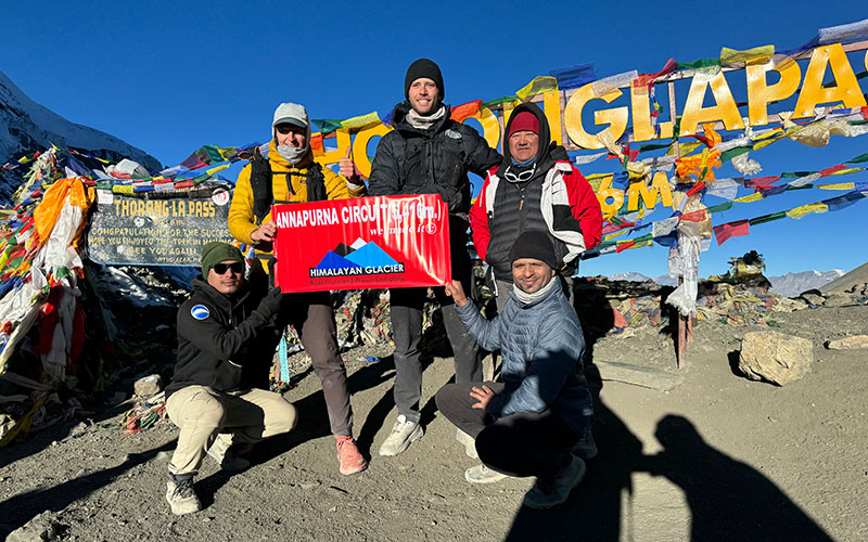
- Reach the summit of Thorong La Pass (5,416m/17,769ft), marked with prayer flags and stone cairns
- Take photos, rest briefly (winds and cold make long stays uncomfortable)
- Begin the long descent to Muktinath (3,710m/12,171ft) over roughly 7-8 km
- Arrive at Muktinath by early afternoon (typically 11:00am – 1:00pm)
The descent from the pass to Muktinath is steep and rocky. Trekking poles are strongly recommended for knee protection on the way down.
When is the Best Season to Cross Thorong La Pass?
The Thorong La Pass trek is open during two main seasons each year. The pass can be closed entirely during winter due to heavy snowfall.
| Season | Months | Conditions | Recommended? |
| Spring | March – May | Clear skies, moderate cold, blooming rhododendrons | Yes – Excellent |
| Pre-monsoon | June – early July | Some clear days but rain increases | Possible but risky |
| Monsoon | July – August | Heavy rain, trail risk, pass often closes | Not Recommended |
| Autumn | September – November | Best visibility, stable weather, peak season | Yes – Best Season |
| Winter | December – February | Heavy snow, pass often closed | Not Recommended |
Most trekkers experience the best conditions in October and November, when skies are crystal clear and mountain views are at their finest. Spring (March to May) is the second-best option, with warmer temperatures and lush landscapes. If you’re planning your trek, check our Best Time to Hike Annapurna Circuit for a detailed seasonal breakdown.
What Gear Do You Need to Cross Thorong La Pass?
Essential Gear Checklist
- Insulated down jacket (rated to at least -10 degrees C)
- Thermal base layers (moisture-wicking)
- Waterproof trekking pants and rain jacket
- Sturdy trekking boots (waterproof, ankle support)
- Trekking poles (essential for descent)
- Buff or balaclava for face protection at the pass
- Gloves (liner + outer shell)
- Warm hat covering ears
- Headlamp with spare batteries
- Sun protection (sunglasses, sunscreen, lip balm), UV is intense at altitude
- Snacks and water – at least 2 liters, consider a thermos of hot tea from High Camp
- Personal first aid kit including Diamox (acetazolamide) if prescribed by your doctor
Our Himalayan Glacier trek guides carry supplemental oxygen and emergency first aid supplies on all Thorong La Pass crossings for added safety.
How Much Does the Annapurna Circuit Trek with Thorong La Pass Cost?
The total cost of trekking Thorong La Pass as part of the Annapurna Circuit depends on the trek package, duration, and services chosen.
| Cost Component | Estimated Range (USD) |
| Guided Annapurna Circuit Trek Package (14-21 days) | $800 – $2,200 |
| TIMS Card (Trekkers Information Management System) | $20 |
| ACAP Permit (Annapurna Conservation Area) | $30 |
| Porter (optional, ~$25-30 per day) | $300 – $450 for full trek |
| Teahouse accommodation (per night) | $5 – $20 |
| Daily meals on trek | $20 – $35 per day |
| Flights Kathmandu to Pokhara (one way) | $80 – $120 |
Budget trekkers (teahouses, no guide) can complete the Annapurna Circuit for $600-$900 total. A fully guided, supported trek with Himalayan Glacier, including all logistics, permits, and professional guide and porter support, typically costs $2,900 – $3,100 depending on duration and group size.
Book Your Annapurna Circuit Trek with Expert Support
Himalayan Glacier is a locally operated Himalayan trekking company with a USA-based customer support office. We handle permits, guides, acclimatization planning, and pass-day logistics so you can focus on the experience.

What Views and Landmarks Can You See at Thorong La Pass?
Reaching the top of Thorong La Pass at 5,416m/17,769ft rewards you with one of the most expansive Himalayan panoramas accessible to trekkers on foot.
Mountains Visible from Thorong La Pass
- Annapurna I – 8,091m (26,545 ft) – World’s 10th highest mountain
- Annapurna II – 7,939m (26,040 ft)
- Annapurna III – 7,555m (24,786 ft) – visible throughout the ascent
- Annapurna IV – 7,525m (24,688 ft)
- Gangapurna – 6,485m (21,276 ft)
- Chulu West – 6,419m (21,060 ft) – frames the ascent trail beautifully
- Yakwakang – 6,462m (21,201 ft)
- Khatung Kang – 6,484m (21,273 ft)
Beyond the mountains, you will see the dramatic shift from the lush Annapurna Conservation Area to the arid Mustang plateau, a contrast that makes this crossing truly unforgettable. The prayer flags at the summit add a spiritual atmosphere that many trekkers describe as deeply moving.
What Safety Risks Should You Know About Thorong La Pass?
Thorong La Pass crossing carries real risks that every trekker must understand. Being informed is the first step to a safe crossing.
Top Safety Risks
- Acute Mountain Sickness (AMS) – the most common risk at this altitude. Ascend slowly and do not skip acclimatization stops.
- HAPE (High Altitude Pulmonary Edema) and HACE (High Altitude Cerebral Edema) – serious medical emergencies. Descend immediately if symptoms are severe.
- Sudden weather changes – blizzards and whiteouts can develop rapidly. Always start before dawn to reach the pass by late morning before afternoon storms.
- Avalanche risk – the slopes above Thorong Phedi can carry avalanche risk in heavy snowfall years.
- Exhaustion and hypothermia – the combination of altitude, cold, and long duration is physically taxing.
Safety Tips from Our Experienced Himalayan Guides
- Never attempt the pass if you have AMS symptoms, always descend first
- Depart from High Camp no later than 5:00am to avoid afternoon wind and weather
- Trek with an experienced, certified guide who knows the route and emergency procedures
- Carry a charged phone with emergency contacts and download offline maps
- Know the symptoms of AMS, HAPE, and HACE before you start the trek
- Drink 3-4 liters of water per day to stay hydrated at altitude
Frequently Asked Questions: Thorong La Pass
Yes, but with proper preparation. Most trekkers who complete the Annapurna Circuit Thorong La crossing are not mountaineers. You need a good level of cardiovascular fitness, ideally 2-3 months of training including hiking, and you must acclimatize properly. Booking with an experienced guide through Himalayan Glacier significantly reduces risk for first-time high-altitude trekkers
Starting from High Camp (4,850m/15,912ft), the crossing to Muktinath (3,710m/12,171ft) takes approximately 7 to 9 hours total. The ascent from High Camp to the pass summit takes 4-5 hours. The descent from the pass to Muktinath takes another 3-4 hours. Starting from Thorong Phedi (4,450m/14,599ft) adds approximately 1.5-2 hours to the ascent.
Thorong La Pass sits slightly higher than Everest Base Camp (5,416m/17,769ft vs 5,380m/17,650ft). In terms of difficulty, Thorong La Pass is considered more physically demanding on pass day due to the very long crossing distance and early start. However, the EBC route has a longer overall trek with more sustained high-altitude exposure. Both are challenging and require good acclimatization.
A guide is not legally mandatory but is very strongly recommended. The trail is well-marked in good weather, but conditions can change rapidly. An experienced local guide from Himalayan Glacier knows the route, monitors for altitude sickness symptoms, can assist in emergencies, and significantly increases the safety and enjoyment of the crossing.
You need two permits: the TIMS Card (Trekkers Information Management System) at approximately $20, and the ACAP Permit (Annapurna Conservation Area Project) at approximately $30. Both are easily arranged in Kathmandu or Pokhara. Himalayan Glacier includes permit assistance for all booked treks.
If Thorong La Pass is closed due to heavy snow or dangerous weather, trekkers must wait at Thorong Phedi or High Camp until conditions improve or turn back. In some cases, rescue or evacuation may be needed. This is why travel insurance that covers helicopter rescue is essential for all Annapurna Circuit trekkers.
Ready to Cross Thorong La Pass? Let’s Plan Together.
Himalayan Glacier – your local Himalayan trekking experts with a USA-based booking and support office will handle every detail of your Annapurna Circuit Thorong La crossing, from permits to acclimatization days to guided pass-day support.

With his past 14 years of experience Pradip Khadka has acquired a vast knowledge of the mountainous life of Nepal. Young and energetic Pradip has led travelers to the most popular trekking destinations in Nepal and been praised for his knowledge, helping nature & his patience by his clients.


